Mt. Qomolangma National Park is now reopened for the medical workers amid coronavirus. As per the Xigaze Tourism Bureau, Tibet, an autonomous region of China, will charge no cost for the medical officers who kept their effort to fight against the global pandemic Coronavirus (COVID-19).
The national park's main attraction is Mount Everest. The park relaunched its services during the five-day May Day holiday.
However, the visitors are not allowed to enter the area of Mt. Qomolangma National Nature Reserve located ahead of the base camp nearby Rongpo Monastery.
Similarly, they are meant to follow strict waste management regulations and environmental protection.
CGTN Revised The Tweet Stating Mount Qomolangma Lies On The China-Nepal Border
Facts suggest that Mount Qomolangma, known as Mount Everest in the west, has its peak located on the Southside, i.e., Nepal. However, the recent tweet of China Global Television Network (CGTN) turned the things into a Twitter feud.
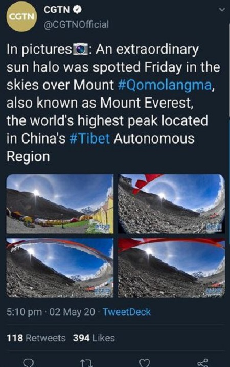
On 2 May 2020, CGTN tweeted that Mount Qomolangma lies in China, which drew an avalanche of critiques from the Nepalese side, directing a great start of Twitter beef.
CGTN shared four pictures on their official Twitter and wrote:
"An extraordinary sun halo was spotted Friday in the skies over Mount Qomolangma, also known as Mount Everest, the world's highest peak located in China's Tibet autonomous region."
With the aggressive notion of disgrace, the Nepalese social media users wrote the words 'BackoffChina' all over Nepal. After the immense criticisms, the tweet has since been deleted.
(©: CGTN's Twitter)
Despite the deletion, the snapshot of CGTN's post has been the talk of the town in South Asia. Some have mentioned that China, who sent a team of surveyors to the Himalayan peak to measure its height, was unethical. They stated that China took the step of measuring Mount Everest without informing Nepal, and CGTN's tweet claiming the highest peak in their region was enough to rage the anger in people.
After the tweet garnered a broad mass of criticism worldwide, especially from Nepal, CGTN revised the tweet mentioning that Mount Qomolangma lies the China-Nepal border. However, they turned off the comment section.
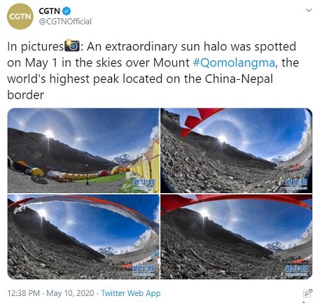
(©: CGTN's Twitter)
Several media outlets mentioned that 'The Everest on the Tibet side is treacherous and less used by China. Moreover, there is no sign of blooming tourism from the Chinese side as of their steep geographical topography and visa issues as well.'
Where Does Mount Qomolangma Lies?
Widely recognized as the highest peak in the world, Mount Qomolangma, also known as Mt. Everest in the west, has been the mesmerizing beauty of the planet. However, several controversies hit the media concerning where it is located.
The debates and disputes arose from many years ago, and the ancestors were able to settle down the disputes via negotiation.
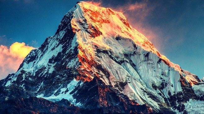
Mount Everest (©: wallpapercave.com)
Mount Qomolangma, also known as Mount Everest in the west, is located on the border of Nepal and Tibet in the Himalayas. Mount Qomolangma is situated in the Mahalangur Range on the Tibetan Plateau, also known as Qing Zang Gaoyuan in Tibet.
As per the China National Surveying and Mapping Administration (2005), the precise location of Mount Qomolangma is 27°59' North latitude, 86°55' East longitudes.
King Mahendra Of Nepal Settled Everest Dispute In the 1960s
There have been piles of debates amongst Chinese and Nepalese Administration regarding the border, one being the Everest dispute.
King Mahendra of Nepal visited China and settled down the Mount Qomolangma, i.e., Mount Everest dispute back in the 1960s. At the time, Nepal-China's boundary treaty got overshadowed by the controversy of Kodari Highway.
Nevertheless, Chinese President Liu Shaoqi and King Mahendra signed the agreement on 5 October 1961, and the Mt. Everest dispute got settled.
Both China and Nepal erected border pillars. Since then, the relationship between China and Nepal has been friendly with mutual understandings and aids.
Facts Regarding The World's Highest Peak
Here are some of the facts regarding Mount Qomolangma, i.e., Mount Everest.
•Qomolangma is a Tibet name for the highest peak in the world. In Tibetan language, Qomolangma means a 'Holy Mother,' and it got first recorded with Chinese transcription on the 1721 Kangxi Atlas.
•The Nepalese name for Mount Qomolangma is 'Sagarmatha.' Here, Sagar means 'sky,' and matha refers to 'forehead.' Before, it had the name of '14th peak' in Nepal.
•The westerners know Mount Qomolangma as 'Mt. Everest', named after the British Geodesist, George Everest in 1865. Fellow of the Royal Society erected Everest in 1827 and knighted in 1861.
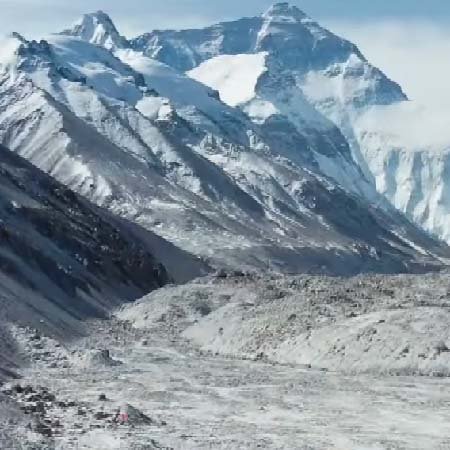
Climbing Route Of Mount Qomolangma From North Ridge In Tibet
Mount Qomolangma has two climbing routes. One is from the Southeast in Nepal, which is also the standard route, and others from the north in Tibet, an autonomous region in China. The Southeast route is often mentioned as the easiest way to the summit, which Tenzing Norgay Sherpa and Sir Edmund Hillary followed in 1953's peak.
From the North ridge in Tibet, the trek starts from base camp at 5,180 m (16,990 ft). The Changste base is situated at 6,100 m (20,000 ft) height, and the climbers have to ascend Camp III (ABC—Advanced Base Camp) located below North Col at 6,500 m (21,300 ft).
The North Col is situated at the height of 7,010 m (23,000 ft), from where the climbers have to ascend Camp V at around 7,775 m (25,500 ft). After that comes Camp VI at 8,230 m (27,000 ft), after which the climbers need to push their summit to the top.